- Added Orthophoto for Norway and Svalbard with Pro+ subscription
- Fixed tiles sometimes becoming blank if panning quickly back and forth.
- Fixed Svalbard FKB map.
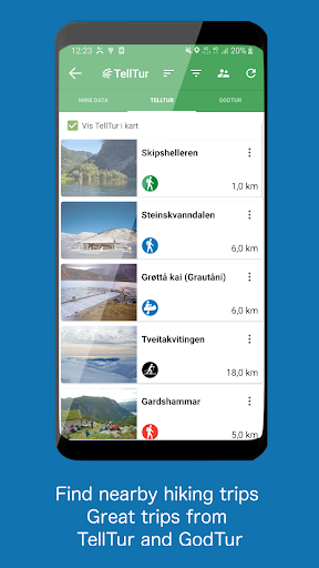
- Added warning to TellTur trips that are not part of this year TellTur competitions (Vesterålen, Midt-Troms and Midtre Hålogaland has left TellTur).
3.22.7:
- Fixed crash introduced in version 3.22.5 when checking for app updates on units with Android 14
- Fixed setting visibilities for categories.
- Prevent duplicates if screen turned on/off during download of data
- Some minor fixes
3.22.5:
- Fix for tracker function
- Fix for selection in map when track start points have been grouped with other objects.
- Fix for setting of visibility from lists when tracks displayed as start points.
3.22.x:
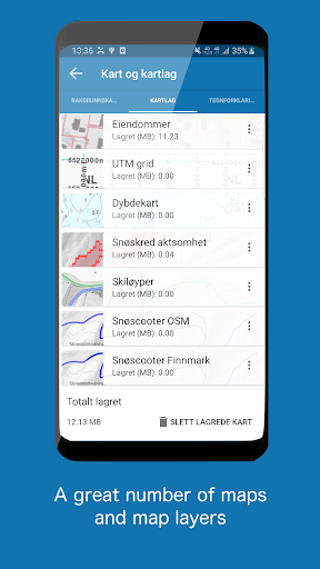
- New Pro+. Add own maps and layers (WMS, WMTS, XYZ, TMS) for UTM33 or Mercator.
- Added support for west and south coordinates.
- Fixed log in on Android 5.x devices
3.22.3:
- Fixed log in on Android 5.x devices
- Some improvements when adding own maps
3.22.x:
- New Pro+. Add own maps and layers (WMS, WMTS, XYZ, TMS) for UTM33 or Mercator.
- Added support for west and south coordinates.
3.22.2: Fixed some crashes
3.22.x:
- New Pro+. Add own maps and layers (WMS, WMTS, XYZ, TMS) for UTM33 or Mercator.
- Now supports Android 5.1 again
- Fixed Jan Mayen map
- Fixed hiding compass and ruler
- Fixed KML import
- New design map screen
- New compass
- Change opacity for layers, lines and areas from new map button.
- Placename displayed in info box
- Duration and length displayed in list of tracks
- Fixes and improvements
- Possible to use copied coordinate in search
- Possible to remove empty Live points categories
- Fixed TellTur company result list
3.19.5:
- Improvements and fixes
3:19.x:
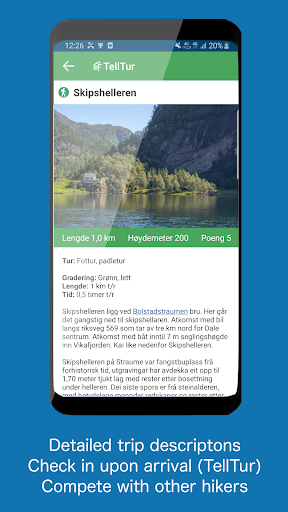
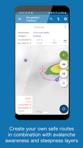
- Long press in map or press the info box to view detailed information about a location in the map
-Map can be rotated freely (turn of in settings)
-Avalanche incidents layer
-Stored map tiles takes up less space
New Pro subscription:
-Create and measure areas
-Turn on multiple layers at the same time
Dynamic points:
-Categories created from KML folders
-Set color and size for KML points of a given category
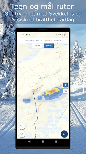
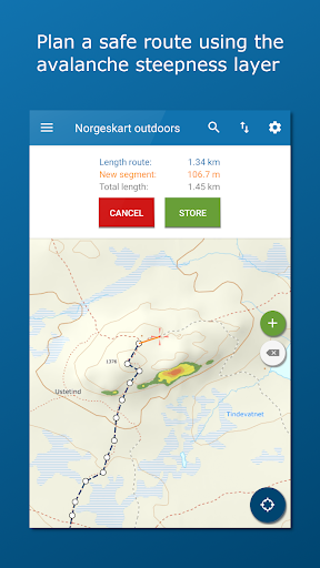
- 2 Avalanche steepness layers (with and without run out zones)
- Possible to adjust opacity of map layers from map info view
- Fixed TellTur visited list for previous years.
- Avalanche steepness now also includes possible track and runout zone
- TellTur free also for 2023
- Some fixes
- Added settings for displaying text in map for points.
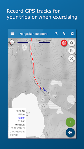
- Improved tracking function.
- Userguide for tracking.
- Fake GPS positions not allowed for TellTur
- Time of GPS location used when checking in TellTur.
- Buttons moved down when object selected in map.
- Fix for export of data
- Added support for image from mymaps KML when using Dynamic points
- Fixed possible crash when screen is turned or app is closed
- Some adjustments to subscription handling. Including possibility to manual refresh subscriptions.
- Fixed app not suggested for some GPX files
- Fixed some possible crashes
3.18.8:
- Fixed Cultural heritage map layer (new service)
- Fixed refresh button for dynamic points not always visible
- Fixed possible crash when selecting group of dynamic points
3.18.4:
Error corrections and minor improvements
3.18.x:
- Added possibility to delete user account from settings
- TellTur user registration and administration
- TellTur visited lists
- TellTur visits marked in map
- TellTur competitions
- TellTur result lists
- TellTur user guidelines
- Fixed map layers from The Norwegian Water Resources and Energy Directorate (NVE).
- Added clearer warning for possible outdated snowmobile layer Finnmark and Troms.
- Added settings for merging segments when exporting tracks to GPX
- New Snowmobile layer from Norwegian Environment Agency.
- Added "Follow on Facebook" to left panel.
- Fixed automatic opening of TellTur check in dialog for Android 12
- Fixed problem with TellTur and some map layers caused by server certificate not working for old Android phones (7.1.1 and older)
3.17:
- Telltur is now free for 2022
- Improved handling of subscriptions with new billing library
- Added user create date to registrations.
- Fixed some errors
3.16.13:
- Fixed crash during tracking that some experiences after last update.
- Fixed opening app from tracking notification.
3.16.12:
- GodTur trip suggestions is now free for all users as GodTur.no is expected to be shut down soon. It is uncertain how long the services will be available.
- Improved calculation of track climb and decline in graphs
- Fixed tracking for Android 12
- GodTur trip suggestions is now free for all users as GodTur.no is expected to be shut down soon. It is uncertain how long the services will be available.
- Improved calculation of track climb and decline in graphs
- Fixed tracking for Android 12
3.16.10:
- Fixed download button sometimes not becoming visible when downloading maps for an area.
- Fixed location updates for android 12 devices
3.16.8/9:
- Fixed writing of GPX-file when storing or sharing routes.
- Nautical miles also displayed when editing route if selected in settings.
- URL links can be selected in TellTur and GodTur.
- Text in TellTur and GodTur descriptions can now be selected and copied.
- Nautical miles also displayed when editing route if selected in settings.
- URL links can be selected in TellTur and GodTur.
- Text in TellTur and GodTur descriptions can now be selected and copied.
- Some fixes.
- Norgeskart Outdoors is now suggested when opening GPX files from DropBox.
- Added out of season warning in TellTur details window.
- Fixed missing start and end date in TellTur details window.
3.16.3:
- Fixed crash at startup for high resolution Android 7 devices
3.16.2:
- Track recording is back. Information to user according to guidelines.
- Added new onboarding screens when app is started first time.
- Information to user if tracking has stopped when app has been closed..
- Improved address search with possibility to search with spelling errors.
- Fixed screen orientation when downloading objects on pads.
- Fixed that subscriptions in some rare cases have been canceled during purchase
- Fixed some crashes
3.15.12:
- Added filtering by name to TellTur and GodTur
- Fixed loading of GPX files from lists.
3.15.10/11:
- Added traffic restrictions (nature) map layer
- GPX can now be opened directly from file browser, attachment and Google drive
- Fixed height of first track point sometimes being off
- App no longer requires file permissions to write and read gpx files
- Improved dialog for loading TellTur family members
3.15.11:
- Fixed crash in TellTur for Android 11 devices caused by 3.15.10
3.14.3:
- Improved user log in. Now also by email.
- Improved subscription administration.
- Added a simple splash screen
3.14.x:
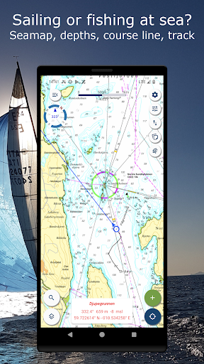
New map layers:
- Lake depths
- Anchorages
- Outports
- Activities (bath spots, camp fires etc)
- Facilities (toilets, parkings etc)
3.14.2:
- Improved scalebar
- Fixed parkings for TellTur.
- Fixed problem with subscriptions affecting a few users
- Minor improvements for downloading of map tiles.
3.14.x:
New map layers:
- Lake depths
- Anchorages
- Outports
- Activities (bath spots, camp fires etc)
- Facilities (toilets, parkings etc)
3.14:
Added new map layers:
- Lake depths
- Anchorages
- Outports
- Activities (bath spots, camp fires etc)
- Facilities (toilets, parkings etc)
- Fixed setting visibility for pois, routes and tracks when in landscape
- Minor fixes for update of placename and altitude in info tool
3.12.10
- Fixed crash that some users experienced after 3.12.9
3.12.9
- Display maps from up to 4 levels above if no maps for current zoom level.
- Possible to start tracking without high accuracy for Location in settings.
- Removed Cultural history as the services has been shut down.
- Reduced number of height requests during panning.
- Fixed display of GPS satellites
- Fixed file browsing no longer working
- Fixed result of pressing info button no longer being displayed.
3.12.x:
- Altitude and place name for location of crosshair
- Coordinate search
3.12.8
- Improved handling of errors from map services when using Load area
3.12.x:
- Improved TellTur check in when no mobile coverage
- Search for UTM and MGRS added
- Improved quality of map display
- Altitude and place name for location of crosshair
- Added coordinate search
- Added TellTur parkings
- TellTur content refreshed daily in list
- Svalbard maps made available for free online
3.12.6
- Changed description of TellTur being free the rest of 2020
3.12.5
- Improved TellTur check in when no mobile coverage
- Fixed download of tiles stopping if network issues
- Fixed crash in TellTur functions after download
3.12.x:
- Search for UTM and MGRS added
- Improved quality of map display
- Altitude and place name for location of crosshair
- Added coordinate search
- Added TellTur parkings
- TellTur content refreshed daily in list
- Svalbard maps made available for free online
3.12.4
- TellTur free the rest of 2020 due to corona
- Fix tracking
- Fix crashes Android 4 devices
3.12.x:
- Search for UTM and MGRS added
- Fixed map performance issues
- Improved quality of map display
- Altitude and place name for location of crosshair
- Added coordinate search
- Added TellTur parkings
- TellTur content refreshed daily in list
- Svalbard maps made available for free online
3.12.3:
- Search for UTM and MGRS added
- Fixed tracking and changed drawing rules.
- TellTur content refreshed daily when opening list
- Mark inactive TellTur destinations
3.12:
- Fixed map performance issues
- Improved quality of map display
- Altitude and place name for location of crosshair
- Added coordinate search
- Added TellTur parkings
- Svalbard maps made available for free online
- Altitude always retrieved when creating/moving POIs
3.12:
- Fixed map performance issues
- Improved quality of map display
- Altitude and place name for location of crosshair
- Improved address search tool with coordinate search
- Added TellTur parkings (must reload data)
- Svalbard maps made available for free online
- Altitude always retrieved when creating/moving POIs
3.12.2:
- Reload map tiles when panning/zooming if old jpg
- Fixed missing device direction in info box
- Fixed map performance issues
- Improved quality of map display
- Altitude and place name for location of crosshair
- Improved address search tool with coordinate search
- Added TellTur parkings (must reload data)
- Svalbard maps made available for free online
- Altitude always retrieved when creating/moving POIs
- Div fixes and improvements.
3.11.1
- Fixed poi categories being exported to server as code-value (introduced in 3.11)
- Fix for export of many tracks to one gpx file (uses less memory)
3.11:
- Share pois, routes and tracks as file (e-mail, google disk etc).
- Support import of gpx from e-mail, google disk etc
- Location of files when read/write can be changed and is remembered.
- Handling of missing GPS permission
- Reduced compass frequency to save battery/improve performance
3.10.3:
- Destination name added to TellTur check in dialog
- Adjusted criteria for checking in Telltur.
Fixed:
- My data lists displaying too many object types.
- Possibility to turn of screensaver.
- Missing times and heights in graphs after importing track edited on web.
New in 3.10.x:
- Mountain bike route layer
- Load map function added to menu in map
- Changed icon for Maps and layers.
- Map attributions only in map details
- Improved presentation of directions
3.10.1/2:
Fixed errors introduced in 3.10:
- TellTur checkin & download
- Some crashes
- UTM layers mixed up
- Opening app from download notification
3.10:
- Mountain bike route layer
- Load map function added to menu in map
- Changed icon for Maps and layers.
- Map attributions only in map details
- Improved presentation of directions
Fixed:
- Address search (new services)
- Cultural heritage layer (new service)
- Download of map area causing vibration on old devices
3.9.3:
- Added direction to crosshair in info box
- Selection dialog always snapped to top of map.
- Fixed "Not able to log in" that occurs on startup for some users
- Some crash fixes
3.9.x:
- Maps are now downloaded in the background!
- Fixed crash for some Android 9 users related to GPS
- Adjusted track filtering
Previous highlights:
- Maps of Sweden, Svalbard and Jan Mayen included in premium!
- Map layer for snowmobile trails
3.9.2:
- Fixed crash when TellTur checkin without GPS
- Fixed possible crash in map lists
3.9:
- Maps are now downloaded in the background!
- Fixed crash for some Android 9 users related to GPS
- Adjusted track filtering
- A couple of other fixes
Previous highlights:
- Maps of Sweden, Svalbard and Jan Mayen included in premium!
- Map layer for snowmobile trails
3.8:
- Maps of Sweden, Svalbard and Jan Mayen included in premium!
- Improved panning and zoom
- Width of lines unchanged when 2x scaling
- Map borders to prevent panning out of map
Fixed:
- Performance issue when switching map projection or app is cold started
- Fixed crash for NGIR strandrydding
Highlights 3.7.x:
- Map layer for snowmobile trails
- TellTur is now part of premium
3.7.3:
- Fixed performance issues in map selector
- Ensured valid log in session for layers that requires log in.
3.7.x:
- Map layer for snowmobile trails
- TellTur is now part of premium subscription
- User informed upon checkin if outside valid period for destination.
- Fixed all known TellTur errors.
- Fixed TellTur download for Premium subscribers. Go to My data - TellTur
3.7.1:
- Fixed all known TellTur errors.
- Fixed TellTur download for Premium subscribers. Go to My data - TellTur
3.7:
- TellTur is now part of premium subscription
- User informed upon checkin if outside valid period for destination.
For data collector users:
- Separator defined in administrator is supported.
- Multi select list is supported
- TellTur is now a part of premium subscription
- User informed upon checkin if outside valid period for destination.
- Visibility of categories such as TellTur and GodTur is remembered across restarts.
For data collector users:
- Separator defined in administrator is supported.
- Multi select list is supported
3.6.6:
- Fixed load map area function
3.6.3:
- Maps stored for the remaining day (pan/zoom non-subscribers).
- Improved readability & zoom for track graphs.
- Improved filtering track log.
- Added sort for when created in My data.
- TellTur/GodTur routes can be hidden from dialog.
- Zoom to route for GodTur.
Field reg users:
- Images not deleted before download.
- If configured, one can do a bounding box download & select what to download.
3.6.4/5:
- Fixed opening graphs from My data.
- Fixed error that affected field reg users.
3.6.3:
- Maps stored for the remaining day (pan/zoom non-subscribers).
- Improved readability & zoom for track graphs.
- Improved filtering track log.
- Added sort for when created in My data.
- TellTur/GodTur routes can be hidden from dialog.
- Zoom to route for GodTur.
Field reg users:
- Images not deleted before download.
- If configured, one can do a bounding box download & select what to download.
3.6.3:
- Map tiles stored for the remaining day during pan/zoom for non-subscribers.
- Improved readability and zoom for track graphs.
- Improved filtering for track log (can be turned off in settings).
- Added sorting for when created to my data lists.
- TellTur/GodTur routes can be hidden from selection dialog.
- Added Zoom to route for GodTur.
Field reg users:
- Images are not deleted before new download.
- If configured, one can do a bounding box download and select what to download.
3.6.2:
- Added open air routes layer (Pro)
- GodTur moved to faster server.
- GodTur fishing category fixed (needs reload)
- Privacy consent dialog fist smaller devices
- Fixed error when reading file into Pois
- Fixed memory crash for some pre Android 7 devices.
3.6.x:
- Name changed to Norgeskart outdoors.
- Trips from www.telltur.no
- Trips from godtur.no
3.6.1:
- Fixed missing TellTur family members.
- Fixed possible crash when sorting lists by GPS
3.6:
- Trip suggestions from godtur.no
- Displays route for TellTur if it exist
- TellTur and culture objects are not deleted during import.
- Added warning when power saving is on during tracking.
- Digitalizing routes no longer requires Pro.
- All map layers requires Pro
- Offline maps requires Pro
Previous:
- TellTur content from www.telltur.no !!
- Name changed to Norgeskart outdoors.
3.5.2: Fixed crashes introduced in 3.5.1
3.5.1:
- TellTur content from www.telltur.no !!
- New location button with menu for rotation.
- Dedicated buttons maps, my data and scale of map.
- Bug fixes
Previous highlights:
- Name changed to Norgeskart outdoors.
- GDPR
- Property borders as own layer for Pro subscription
3.4:
- Name of app changed to "Norgeskart outdoors"
- Accept of new privacy policy according to GDPR for logged in users.
- Permissions are acquired when needed, not at install (Android >= 6.0)
- Internal filebrowser instead of relying on external browsers.
- Improved handling of errors from map services during download (Especially overuse)
3.4.2 fixes crashes introduced in 3.4 for some users
Previous:
- Property borders as own layer for Pro subscription
The topographical maps no longer contains cadastre information as it is removed from the new map service from the Norwegian mapping authorities. Cadastre information can now be found as a map layer available to our Pro users.
3.3.27:
- Fixed issue with image upload for field registration users
The topographical maps no longer contains cadastre information as it is removed from the new map service from the Norwegian mapping authorities. Cadastre information can now be found as a map layer available to our Pro users.
3.3.28:
- Minor fixes
We wish all our users a happy Easter holiday. Try out our pistes map layer for alpine- and cross country skiing. Available to our Pro users.
3.3.26:
- Fixed problem that affected upload of tracks and routes for some users
- Fixed some crashes
The topographical maps no longer contains cadastre information as it is removed from the new map service from the Norwegian mapping authorities. Cadastre information can now be found as a map layer available to our Pro users.We are happy to reintroduce a pistes map layer for alpine- and cross country skiing for our Pro users. The service is now running on our own server.3.3.25:- Fixed some possible crashes
The topographical maps no longer contains cadastre information as it is removed from the new map service from the Norwegian mapping authorities. Cadastre information can now be found as a map layer available to our Pro users.We are happy to reintroduce a pistes map layer for alpine- and cross country skiing for our Pro users. The service is now running on our own server.3.3.24:- Fixed wrong message to user after download of maps- Fixed a possible crash on selection of object
The topographical maps no longer contains cadastre information as it is removed from the new map service from the Norwegian mapping authorities. Cadastre information can now be found as a map layer available to our Pro users.We are happy to reintroduce a pistes map layer for alpine- and cross country skiing for our Pro users. The service is now running on our own server.
We are happy to reintroduce a pistes map layer for alpine- and cross country skiing for our Pro users. The service is now running on our own server. Please let us know if you see something that should be styled differently regarding this layer.We can be contacted by e-mail norgeskart@avinet.no.
3.3.20:-Minor changes for field registration users3.3.x-Fixed retrieval of POI height-Fixed upload when track prev not uploaded has been edited-Pro: Delete also deletes on server-Click on selected map layer deselects-Sort lists by title-Hide/show all inn lists-Supports geo intent from other apps-Removed pistes-Weakened ice-Steepness-Ski condition-Legend for snow layersWe can be contacted by e-mail norgeskart@avinet.no.
3.3.19:-Minor changes for field registration users3.3.x-Fixed retrieval of POI height-Fixed upload when track prev not uploaded has been edited-Pro: Delete also deletes on server-Click on selected map layer deselects-Sort lists by title-Hide/show all inn lists-Supports geo intent from other apps-Removed pistes-Weakened ice-Steepness-Ski condition-Legend for snow layersWe can be contacted by e-mail norgeskart@avinet.no.
3.3.18:-Minor fixes for field registration users3.3.x-Fixed retrieval of POI height-Fixed upload when track prev not uploaded has been edited-Pro: Delete also deletes on server-Click on selected map layer deselects-Sort lists by title-Hide/show all inn lists-Supports geo intent from other apps-Removed pistes-Weakened ice-Steepness-Ski condition-Legend for snow layersWe can be contacted by e-mail norgeskart@avinet.no.
3.3.17:-Minor fixes for field registration users3.3.x-Fixed retrieval of POI height-Fixed upload when track prev not uploaded has been edited-Pro: Delete also deletes on server-Click on selected map layer deselects-Sort lists by title-Hide/show all inn lists-Supports geo intent from other apps-Removed pistes-Weakened ice-Steepness-Ski condition-Legend for snow layersWe can be contacted by e-mail norgeskart@avinet.no.
3.3.15:-Minor fixes for field registration users3.3.x-Fixed retrieval of POI height-Fixed upload when track prev not uploaded has been edited-Pro: Delete also deletes on server-Click on selected map layer deselects-Sort lists by title-Hide/show all inn lists-Supports geo intent from other apps-Removed pistes-Weakened ice-Steepness-Ski condition-Legend for snow layersWe can be contacted by e-mail norgeskart@avinet.no.
3.3.14:-Crash fix3.3.x-Fixed retrieval of POI height-Fixed upload when track prev not uploaded has been edited-Pro: Delete also deletes on server-Click on selected map layer deselects-Sort lists by title-Hide/show all inn lists-Supports geo intent from other apps-Removed pistes-Weakened ice-Steepness-Ski condition-Legend for snow layersWe can be contacted by e-mail norgeskart@avinet.no.
3.3.12-Fixed crash when creating POI-Fixed crash when area for map download outside Norway-Some fixes and changes for our field registration customers3.3.x-Pro: Delete also deletes on server-Click on selected map layer deselects-Sort lists by title-Hide/show all inn lists-Supports geo intent from other apps-Warning when deleting individual map caches-Removed pistes-Weakened ice-Steepness-Ski condition-Legend for snow layersWe can be contacted by e-mail norgeskart@avinet.no.
3.3.8:-Map layer selector: Click on selected deselects-Sort data lists by title-Hide/show all inn data lists-Fixed most common crashes3.3.x:-Removed pistes layer-Supports geo intent from other apps-Track and route lists remembers visibility after sync with server-Warning when deleting individual map caches-Weakened ice layer-Steepness layer-Ski condition layer-Legend for snow layersWe can be contacted by e-mail norgeskart@avinet.no.
3.3.7:- Fixed crash when inserting POI (introduced in 3.3.6)3.3.6:- Fixed crash when displaying notifications from developer3.3.x:- Removed pistes layer- Supports geo intent from other apps- Track and route lists remembers visibility after sync with server- Warning when deleting individual map caches-Weakened ice layer-Steepness layer-Ski condition layer-Legend for snow layersWe can be contacted by e-mail norgeskart@avinet.no.
3.3.6:- Fixed possible crash when displaying notifications from developer3.3.x:- Removed pistes layer (caused No access in map)- Supports geo intent from other apps- Fixed resolution indicator when map is scaled (2x etc)- Track and route lists remembers visibility after sync with server- Warning when deleting individual map caches-Weakened ice layer-Steepness layer-Ski condition layer-Legend for snow layersWe can be contacted by e-mail norgeskart@avinet.no.
3.3.4:-Removed pistes layer (caused No access in map)-Supports geo intent from other apps-Added notifications from developer3.3.x:- Fixed resolution indicator when map is scaled (2x etc)- Track and route lists remembers visibility after sync with server- Warning when deleting individual map caches-Weakened ice layer-Steepness layer-Ski condition layer-Legend for snow layersWe can be contacted by e-mail norgeskart@avinet.no.